
|
|
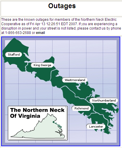
Outage map |
|---|
| This is our outage map. |
|---|
|
I was not really sure where to put this mapset information. Some may say it
does not fit under a Mapviewer project, but since it is usingtha mapviewer,
I have chosen to keep it here.
The primary technology behind the map viewer isn't being used at all. The Partner map viewer is being used as a data source and integration hub. Here were some of our data requirements:
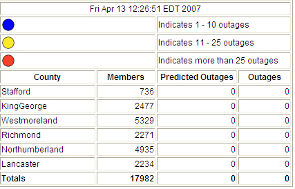
The application pulls outage data from the dataVoice IMS system and then looks up consumers in our Map Viewer. Since the Partner Map Viewer has the associated data (not just location, but also their street address and county), statistics can then be generated by iterating through all the consumers. The script then posts the results to a webpage, which is FTP'd to the public website, using a scheduled FTP script. The data in the Map Viewer is created by the Partner Map Translator tool. This combines multiple data sources into a single seamless map. In Northern Neck's case, the data is largely a combination of Origin GIS and Daffron CIS information.
Quote from Paul Reavis (Partner Software):
Mike worked with one of our developers, Brad Gray, during our spring development workshop to build this tool. He has released it as open-source and we're publishing it on our developer website for other customers to use a nd learn from. Brad is currently working with Brent Wegmann (bwegmann@mvec) at Maquoqueta Valley, Iowa to install it for them. |
  |